Map Index: Illustrative maps in articles (main project)
Page 1


Natural Environment
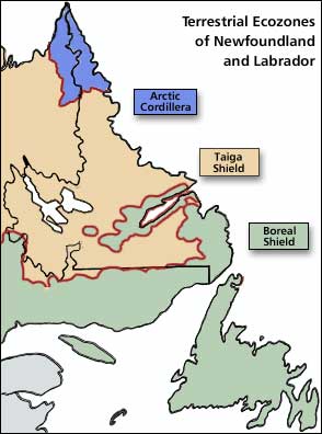
Terrestrial Ecozones of Newfoundland and Labrador
Map by Tina Riche. ©2002, Newfoundland and Labrador
Heritage Web Site Project.
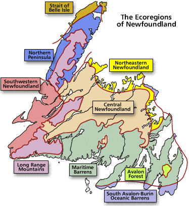
The Ecoregions of Newfoundland
Map by Tina Riche. ©2002, Newfoundland and Labrador
Heritage Web Site Project.
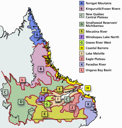
The Ecoregions of Labrador
Map by Tina Riche. ©2002, Newfoundland and Labrador
Heritage Web Site Project.
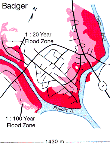
Badger Flood Risk Zone Map
Courtesy of MUNCL, © 1998. From Wasi Ullah et al., Water Resources Atlas of Newfoundland(St. John's, Newfoundland: Water Resources Division, Department of
Environment and Lands, ©1992) 45.
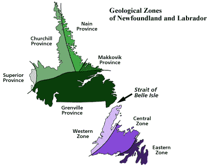
Geological Zones of Newfoundland and Labrador
Illustration by Duleepa Wijayawardhana, 1998.
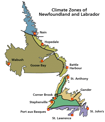
Climate Zones of Newfoundland and Labrador
Image modified by Duleepa Wijayawardhana with permission, 1998. Reproduced by
permission of Gary E. McManus and Clifford H. Wood, Atlas of Newfoundland and Labrador
(St. John's, Newfoundland: Breakwater, ©1991 MUNCL) Plate 6.1.
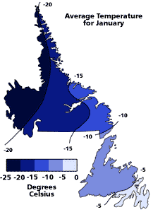
Average Air Temperature for January
Image modified by Duleepa Wijayawardhana with permission, 1998. Reproduced by
permission of Gary E. McManus and Clifford H. Wood, Atlas of Newfoundland and Labrador
(St. John's, Newfoundland: Breakwater, ©1991 MUNCL) Plate 6.5(a).
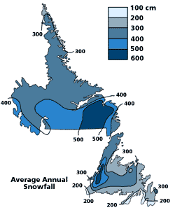
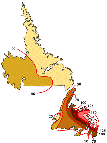
Average Annual Snowfall
Image modified by Duleepa Wijayawardhana with permission, 1998. Reproduced by
permission of Gary E. McManus and Clifford H. Wood, Atlas of Newfoundland and Labrador
(St. John's, Newfoundland: Breakwater, ©1991 MUNCL) Plate 6.3.
Annual Average Number of Hours with Freezing Rain and Freezing Drizzle
Adapted by Duleepa Wijayawardhana with permission of MUNCL, 1998. From Joyce and Alan Macpherson, The Natural Environment of Newfoundland and Labrador, Past and Present (St. John's, Newfoundland: Department of Geography, Memorial University of Newfoundland and Labrador, ©1981)118.
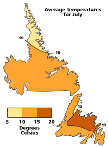
Average Air Temperature for July
Image modified by Duleepa Wijayawardhana with permission, 1998. Reproduced by
permission of Gary E. McManus and Clifford H. Wood, Atlas of Newfoundland and Labrador
(St. John's, Newfoundland: Breakwater, ©1991 MUNCL) Plate 6.5(b).
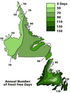
Annual Number of Frost-Free Days
Image modified by Duleepa Wijayawardhana with permission, 1998. Reproduced by
permission of Gary E. McManus and Clifford H. Wood, Atlas of Newfoundland and Labrador
(St. John's, Newfoundland: Breakwater, ©1991 MUNCL) Plate 6.4.
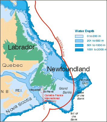
Continental Shelf
Courtesy of MUNCL, ©1998.
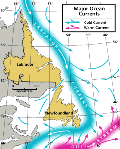
Major Ocean Currents
Image modified by Duleepa Wijayawardhana with permission, 1998. Reproduced by
permission of Gary E. McManus and Clifford H. Wood, Atlas of Newfoundland and Labrador
(St. John's, Newfoundland: Breakwater, ©1991 MUNCL) Plate 5.2.
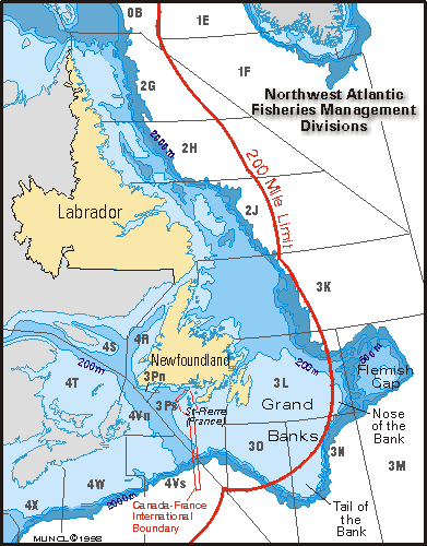
Fishing Banks and Management Zones
Courtesy of MUNCL, ©1998.
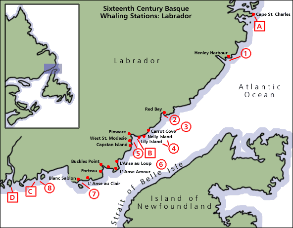
16th Century Basque Whaling Stations
C.W. Sanger. Adapted by Duleepa Wijayawardhana, 1998.
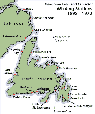
Newfoundland and Labrador Whaling Stations, 1898-1972
C.W. Sanger. Adapted by Duleepa Wijayawardhana, 1998.
Once Upon a Mine
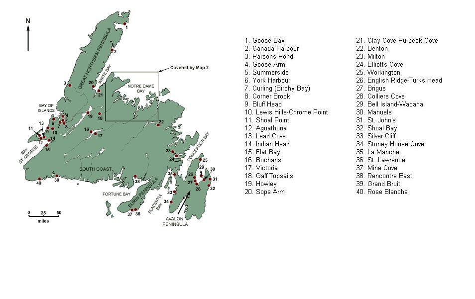
Map 1: Mines and Quarries of Newfoundland
Wendy Martin's Once Upon a Mine: Map 1
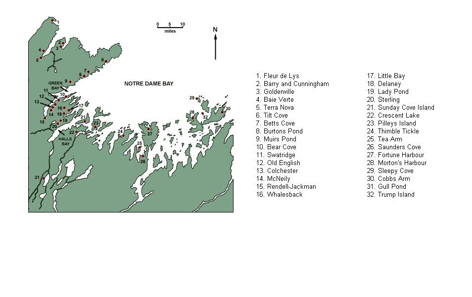
Map #2: Mines of Notre Dame Bay
Wendy Martin's Once Upon a Mine: Map 2
